


la tour d'Auvergne la Stele

Fauvette 44
User
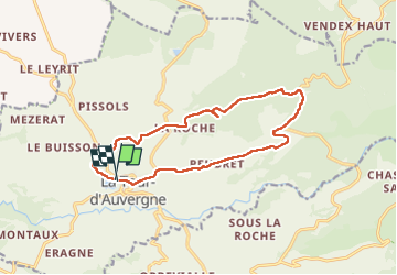

Length
14.3 km

Max alt
1276 m

Uphill gradient
355 m
Km-Effort
19 km

Min alt
924 m

Downhill gradient
351 m
Boucle
Yes
Creation date :
2022-06-27 12:18:01.781
Updated on :
2022-06-27 15:55:33.867
3h20
Difficulty : Difficult

FREE GPS app for hiking
 SityTrail
IGN / Geographical institutes
SityTrail Plus
The world is yours!
About
Trail Walking of 14.3 km to be discovered at Auvergne-Rhône-Alpes, Puy-de-Dôme, La Tour-d'Auvergne. This trail is proposed by Fauvette 44.
Positioning
Country:
France
Region :
Auvergne-Rhône-Alpes
Department/Province :
Puy-de-Dôme
Municipality :
La Tour-d'Auvergne
Location:
Unknown
Start:(Dec)
Start:(UTM)
475475 ; 5042438 (31T) N.
Comments